


Voting District RVRD, Beaufort County, North Carolina
About
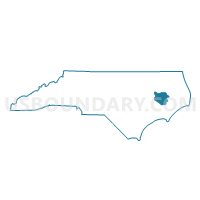
Outline

Summary
| Unique Area Identifier | 639321 |
| Name | Voting District RVRD |
| County | Beaufort County |
| State | North Carolina |
| Area (square miles) | 7.05 |
| Land Area (square miles) | 5.12 |
| Water Area (square miles) | 1.93 |
| % of Land Area | 72.58 |
| % of Water Area | 27.42 |
| Latitude of the Internal Point | 35.49897180 |
| Longtitude of the Internal Point | -76.98594240 |
Maps


Graphs
Select a template below for downloading or customizing gragh for Voting District RVRD, Beaufort County, North Carolina


Neighbors
Neighoring Voting District (by Name) Neighboring Voting District on the Map
- Voting District CHOCO, Beaufort County, NC
- Voting District GILEA, Beaufort County, NC
- Voting District WASHP, Beaufort County, NC
- Voting District WDPD, Beaufort County, NC
Top 10 Neighboring County Subdivision (by Population) Neighboring County Subdivision on the Map
- Chocowinity township, Beaufort County, NC (9,290)
- Long Acre township, Beaufort County, NC (9,185)
- Pantego township, Beaufort County, NC (6,685)
Top 10 Neighboring Place (by Population) Neighboring Place on the Map
Top 10 Neighboring Unified School District (by Population) Neighboring Unified School District on the Map
Top 10 Neighboring State Legislative District Lower Chamber (by Population) Neighboring State Legislative District Lower Chamber on the Map
Top 10 Neighboring State Legislative District Upper Chamber (by Population) Neighboring State Legislative District Upper Chamber on the Map
Top 10 Neighboring 111th Congressional District (by Population) Neighboring 111th Congressional District on the Map
Top 10 Neighboring Census Tract (by Population) Neighboring Census Tract on the Map
- Census Tract 9310, Beaufort County, NC (6,051)
- Census Tract 9305.01, Beaufort County, NC (4,845)
- Census Tract 9309, Beaufort County, NC (3,904)
- Census Tract 9305.02, Beaufort County, NC (3,469)
- Census Tract 9306, Beaufort County, NC (3,224)